


10 Places for the Best Photographs on Mount Kilimanjaro

Here are 10 Places for the Best Photographs on Mount Kilimanjaro. Kilimanjaro climbing is a once-in-a-lifetime experience. Thousands of tourists visit Africa’s highest peak each year to try their luck.
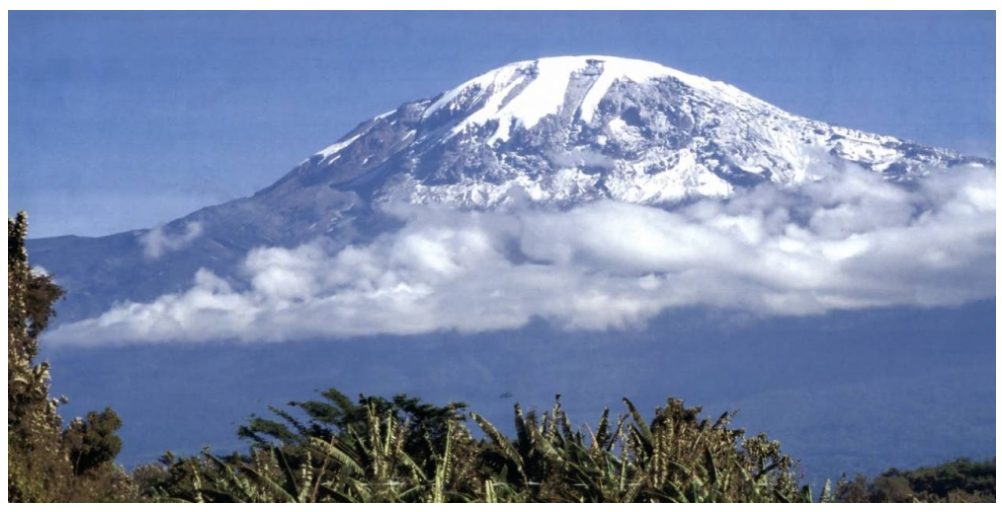
Tanzania is home to Mount Kilimanjaro, the world’s tallest free-standing peak that is not a part of a mountain range. As one might anticipate, there are plenty of chances to take breathtaking, jaw-dropping pictures while here.
Made of rock, ash, and lava, the 19,341-foot-tall mountain is a stratovolcano. Shira, Mawenzi, and Kibo, three volcanic centers, erupted to form it 750,000 years ago. Climbers traverse five different ecological zones on their way up Kilimanjaro, each of which has unique scenic features.
Here are our top ten recommendations for the most picturesque locations on Mount Kilimanjaro.
So take out your camera and let’s start our visual exploration.
1. The Shira Plateau
About half a million years ago, the Shira cone became extinct. Later, it fell, creating the Shira Plateau. The 24 square mile area is located at an elevation of 12,500 feet (3,800 meters) west of the peak.
Shira Plateau is where climbers on the Shira Route, Lemosho Route, and Northern Circuit Route will first see Mount Kilimanjaro.
2. Lava Tower
When lava erupted from a vent and cooled and solidified, it prevented the flow of subterranean lava from rising to the surface, creating the volcanic rock tower known as Lava Tower. We call this a volcanic plug.
The 300-foot-tall formation serves as a prominent, noticeable signpost along the trail. Previously, park officials permitted visitors to climb to the summit of the tower before deciding it was too risky.
Climbers will come across Lava Tower on the Shira, Lemosho, Machame, and Northern Circuit routes.
3. Barranco Wall
A portion of Kibo’s crater rim collapsed, leaving behind this enormous and menacing structure known as the Barranco Wall. The wall rises above the valley by 843 feet (257 meters).
When they see this seemingly sheer cliff, many people become anxious. This rock is actually one of the most enjoyable parts of the climb, and navigating it is much safer and easier than it appears.
The best time to take pictures is when you get to the top of Barranco Wall, where the clouds and blue sky provide a striking backdrop.
Climbers will ascend the Barranco Wall via the Shira, Lemosho, Machame, and Umbwe routes.
4. The Saddle
“The Saddle” is a desolate alpine desert area that lies between Kibo and Mawenzi. This is Africa’s largest high-altitude tundra, covering an area of roughly 14 square miles. There are breathtaking views of Kibo to the west and Mount Mawenzi to the east.
On their way to the summit, climbers following the Rongai and Marangu routes will traverse the Saddle.
5. The Mawenzi Peak
The second-highest summit on Mount Kilimanjaro is Mawenzi. At a height of 16,893 feet or 5,149 meters, this area is made of a very steep terrain and loose rocks. It is unique in appearance due to its spiky and jagged top.
Because fatalities have occurred in the past, it was closed to mountaineers for a long time. But recently it has reopened for technical climbers willing to face the potential hazards.
Climbers on the Marangu Route and Rongai Route will have wonderful views of Mawenzi from camp. However, Mawenzi is observable from all of Kilimanjaro’s routes.
6. Barranco Valley
The Great Barranco Valley sits south of Kilimanjaro’s summit. The valley bottom is a moorland environment dominated by a gigantic groundsel known as Dendrosenecio kilimanjari.
These striking succulents, which appear like they are from out of this world, are found only on Mount Kilimanjaro. Be sure to shoot some shots at the Senecio woodland shown above.
Climbers on the Shira Route, Lemosho Route, Machame Route and Umbwe Route will camp at Barranco Valley.
7. Southern Ice Field
Despite being close to the Equator, Kilimanjaro has an ice crown on its summit. Its famous glaciers, which have encased Africa’s highest peak for ages, are drastically receding in recent years. Try to catch them while they’re still around.
As you get closer to the summit, you’ll be able to see the Southern Ice Field from every route on Kilimanjaro. It will be well worth the effort to take a picture with them before you descend.
8. The Crater Camp
Crater Camp is a small, abandoned camping site close to the top. It is the mountain’s highest campsite at 18,865 feet (5,750 meters).
Climbers who stay here extend their itineraries by one day. However, in return, they get to see Furtwangler Glacier, one of Kilimanjaro’s last surviving glaciers. They can also ascend to the edge of the crater.
Our Northern Crater Route and Lemosho Crater Route both use Crater Camp.
9. Uhuru Peak
Mount Kilimanjaro’s highest point, Uhuru Peak, is 19,340 feet (5,895 meters) above sea level. You will know you’ve reached the top when you see this sign! In Swahili, Uhuru signifies “freedom.”
There is a wooden sign indicating the location of the required summit photo. Every journey, of course, ends here, on Uhuru Peak.
10. Reusch Crater
Reusch Crater is a crater atop Kibo, the tallest of Kilimanjaro’s cones. The south side of the crater had inner walls as high as 600 feet (180 meters) when the main crater floor partially collapsed. The Reusch Crater contains the Ash Pit.
According to scientists, Kibo last erupted 360,000 years ago. Although inactive, the volcano could erupt once more.
On our Lemosho Crater Route and Northern Crater Route, you can choose to see Reusch Crater. The climb to the crater takes an hour from Crater Camp.
Bonus: From Above
The mountain itself is inaccessible for this shot. However, if you’re fortunate, you may be able to see Kilimanjaro up close. Keep the window shade open and prepare to take a breathtaking picture.
From the air, you will be able to appreciate the enormity of what you have done. The Ash Pit, Reusch Crater, the Southern and Northern glaciers, and the Uhuru Peak sign should all be visible.

